Thursday, February 24, 2022

To Stave Off Despair

 I have my reasons for choosing to run from Metro stations rather than to them. Mostly it is because I am gross and/or cold after I run and don't want to take the train home after a run. After my most recent terrible uphill run and my subsequent looking for long runs that aren't all uphill, I decided to change my mind.  If I want to risk the cold or dirty looks because I smell or drip on the way home, that's okay. From here on out, my goal will be to cycle, run, or walk to every Metro station from my neighborhood or home from every Metro station to my neighborhood.

So say we all.

Sunday, February 20, 2022

McPherson Square Run: The Wind Was Angry That Day

There are good runs and bad runs, my friends. This one was a bad run.

Selfie of me in front of an escalator and a sign reading "McPherson Square"
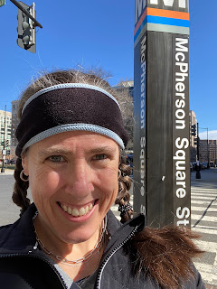
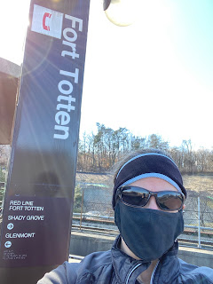
Pre-run. Look at the optimism in my eyes!

I was excited for this one too. I had an easy 10-mile run scheduled for this week and I figured I could run straight up Connecticut from downtown DC to my neighborhood. 

"Ugh, that'll be all uphill," said Alex, who drives Connecticut two times every day.

"No, it's more of a rolling hills situation," said I, who runs on Connecticut every once in a while.

Elevation map showing a few downs, but mostly up, up, up.
Guess who was right?

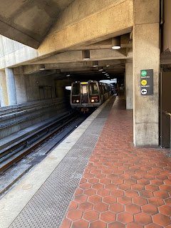
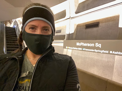
Let's just let that sink in for a while as we get to know McPherson Square. This Metro station serves the Orange, Silver, and Blue Lines and is located in downtown DC. It is a two-platform indoor station with an excellent viewpoint for photo taking.

Photo of both platforms of the Metro station from above.
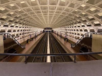
Weirdly, there were two other people taking similar photos at the same time.

It's not a hugely remarkable station in any way other than its proximity to some cool places, but it does have some art on the wall to commemorate veterans.

Red-toned mural
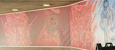
There are other panels I didn't photograph because there was a homeless guy sitting in front of them and I didn't want to be an asshole.

There was also a pigeon, which I mention because I didn't see any crows, but pigeons, while less smart than crows, are similarly delightful in their scavenging and willingness to hang out near humans.

This station is located near McPherson Square. Which seems obvious, but not everything in city planning in obvious. McPherson Square is named after James B. McPherson, who was a major general in the Union Army during the Civil War.

Photo of McPherson Square with a sign in the forefront identifying it as such. You can see a statue.
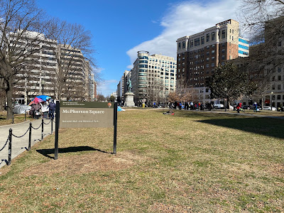
There's a statue of the guy right back there in the middle.

McPherson Square is similar to lots of other downtown DC park-like blocks. Fun fact: I work right near here!

There are a lot of cool places to see near here, including the White House and Black Lives Matter Plaza. There is also the Subway sandwiches shop where I bought an oatmeal cookie so I could use the bathroom. Fun fact: This is the Subway sandwiches shop where I buy my morning fountain soda to take to work!

A lamppost with brown and black banners on it with lists of victims of police violence and the hashtag #SayTheirNames
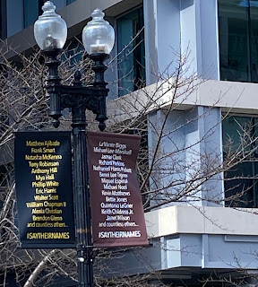
Banners at Black Lives Matter Plaza

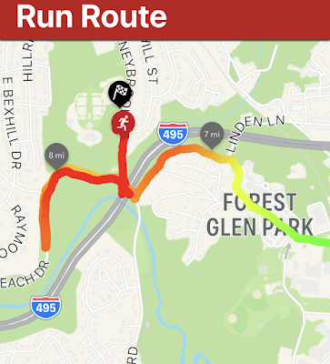
I took a quick little run tour of the sights and local bathrooms, then headed over to Connecticut Avenue to start my run home. I'd show you a picture of the map, but it's really just a straight orange line. 

Screenshot of a map of DC/Maryland with an orange line leading straight out of it.
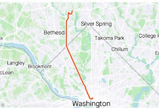
I can't not do it, for some reason.

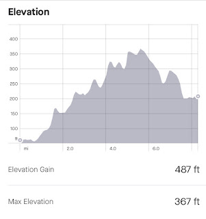
Anywho, I set off UP Connecticut and soon discovered that the wind advisory put out by the National Weather Service was put out for a reason. That wind was not fucking around and it was right in my face the entire way. It was genuinely A Thing.

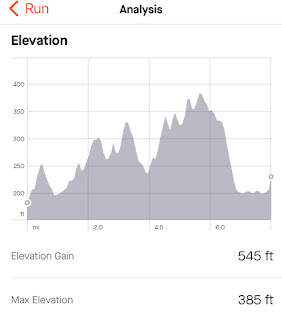
I don't know if it was the hills or the wind or I was just tired and burnt out, but this run was grueling for me. I also had a hard time finding my groove because running out of DC involves a lot of stop lights. I was way sad by the time I hit three and a half miles. Mile four was a tough one.

I made it all the way to five miles before I got sad enough to sit on a bench and feel bad about myself and my life choices. During this sit, I watched a metal sign across the street be battered and shook by the wind and I felt devastated for it and myself.

Selfie of me making a face.
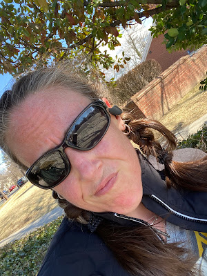
This is the face of someone only halfway through a run she really doesn't want to do.

I texted Alex for encouragement, which went unanswered (evidently he has his own life) then decided I should keep going at a slow run with some walk breaks thrown in. I already wasn't going to get ten straight running miles in, so I decided to at least bank some time on my feet. I was also approaching the part of my run that was less extremely uphill.

I pulled my shit together and shuffled up the street again. There was a minor car crash blocking the road at one point, so for two amazing blocks, I was moving faster than the traffic. I was blazing fast! Or not.

Screenshot of my splits from mile 1 to 10. They rance from 12:09 to 18:14.
I'm not proud of this.
Eventually I made it close enough to my house to give up. I had apparently done some wacky pausing of my watch or maybe I paused it a stoplight and forgot to turn it on for a while, but that watch said I only went just over eight miles.

I gave not a single fuck.

I was very proud of myself for pushing through and making it home on my own feets. I figure that every training cycle has at least one terrible run. I'm hoping this one was it for this cycle. There are plenty of Metro stations that can let me run up Connecticut. Maybe I'll try again someday, but for next week I'm going to try running somewhere other than the "rolling hills" of Connecticut Avenue.

STATS:

Selfie of me in front of the McPherson Square Metro pillar.


Metro station: McPherson Square
Line: Orange, Silver, & Blue Lines
Distance: 8.31
Time: 1:44:03
Pace: 12:31
Crow sightings: 0
Interesting tidbit: These stats reflect my run time/pace/distance. My elapsed time/pace/distance was different. It was longer, for sure, but it also included a fair amount of (watch paused) moping time, slowing my pace down significantly.

Wednesday, February 9, 2022

Fort Totten Run: Not Quite Far Enough Away

 I am currently training for a half marathon, so I am finally running long enough to make it home from Metro stations. In fact, when I arrived at my end point for this run, I still had another mile to run and had to do a little out and back loop after the route I'd planned. My required mileage for this week's long run was 8 miles, so I chose Fort Totten, which turns out to be 7 miles away from my neighborhood.

 Fort Totten is on my regular commuting route, so I see it a lot. It is also the transfer station closest to my house, so if I am switching Metro lines, this is often where I do it. Ergo, I am very familiar with this station.

That said, I just uncovered a ton of veeeeerrrrrry interesting information. But first, the basics. Fort Totten is a three-story open-air station with the Red Line running through the top and the Green and Yellow Lines running through the bottom. It is the last DC Metro stop before the train enters Maryland.

Red Line Metro train leaving an open air station with a Fort Totten sign
Red Line leaving.
Green Line Metro train exiting a tunnel into the Fort Totten Metro station
Green Line arriving.
In 2009, there was a terrible accident when a train headed to Fort Totten during rush hour hit a stopped train in front of it, resulting in nine deaths and at least 80 injuries. There is a memorial plaque in the station, but I have never noticed it, only learning of its existence from the station Wikipedia page. I remember when this accident happened. It was awful.

Deep cleansing breath.

On my commute, I have watched a the progress of a trail expansion happening at the station. I so badly want to run on that clean, new trail. It looks really exciting.

Photo of a sign explaining where the construction is and how it affects pedestrian and bike access
It's hard to see the trail from the platform, so this map will have to do.

Before I get into my run, however, here's something interesting: In an article published -- oh shit -- today, it was reported that an unexploded shell discovered in the construction area last summer is -- again, oh shit -- a chemical fucking weapon. I'm not quite sure what that all means, but it seems to be connected to the Spring Valley cleanup, which I am uninformed about, but was apparently undertaken at a site referred to as "the mother of all toxic dumps." Huh. It'll be interesting to see how that shakes out.

Deep cleansing breath.

My run path was a zigzag north and west, taking me to 16th Street, which I ran out of DC and into Silver Spring.

Strava map of my route. It leads up and left out of DC into Maryland
I switched from Garmin to Strava and I'm not sure I like this map.

The path itself was okay. But the thing that was exciting was my elevation graph. Fortunately, I was supposed to be running slow and easy so it wasn't too rough.

Graph showing a jagged up and down elevation graph with an elevation gain totalling 545 feet
Am badass.

There were stairs -- STAIRS -- on my sidewalk route coming into Maryland. Then there was a lot of fun downhill. 

Once I realized how close I was to my home, I was a little concerned, because my training plan said I had to run 8 miles and I was sure I was only at 5+. Happily, when I checked my watch, I was actually at 6+, so by the time I got to my neighborhood, I only had to run an extra one mile instead of two. That said, it was incredibly sad to bypass my usual exit point and have to run another half mile out and half mile back.

In addition to Strava, I have the Zombies, Run! app going on my phone during runs, so I have a more detailed map of that last, oh-so-sad mile.

Screenshot showing my path back and forth. The line indicating my path becomes steadily darker as I close in on 8 miles.
See how I got steadily slower, as indicated by the line turning from green to dark red?

I have a Project Crow run planned for my 9-mile long run next weekend, but I am planning a route of 9.5 miles to make sure I don't have to take that dispiriting mile jog at the end. See you then!

STATS:

Photo of Jean wearing a mask standing in front of a Fort Totten tower sign

Metro station:
Fort Totten
Line: Transfer station for Red, Green, and Yellow Lines
Distance: 8.01 miles
Time: 1:40:28
Pace: 12:32 min/mi
Crow sightings: Two and a half! I saw two crows at my boarding station and I heard a crow on my run but couldn't locate it. So half.
Interesting tidbit: Alex (husband) was also going on a run when I was. We started in radically different spots, we run very different paces, we ran different mileage, and we started out in different directions. The road I was on at mile seven and the road he was on at mile nine intersect with each other and we both hit that intersection at THE EXACT SAME TIME. It was crazy weird.