Thursday, September 26, 2019

Forest Glen Cycle: I Can Ride a Bike!

I'll be honest here. I mostly included cycling in Project Crow because I needed a "C" for crow. I've had a bike for a while, but I rarely ride it. I want to be a cyclist, but I'm all kinds of scared about it. But I've had a shin injury recently that has kept me from running at all, so if I have any plans to Crow about DC, I'm going to need to get on my bike.

The thing about cycling home from a Metro station is that you have to take your bike on the Metro to get to the starting station. I decided I didn't want to have to jam my bike into my minivan and drive to my home Metro station, so I decided my first bike excursion would be to figure out exactly how the hell to ride from my neighborhood to Forest Glen. Unfortunately, the roads between there and my home are not bicycle friendly. I rarely see cyclists on them and there are cyclists who ride everywhere!

I deduced that there have to be other ways to get to the station without taking a million-mile detour around Wheaton to get there so I took to Google Maps and did some close-up inspecting of the satellite images to find a route that avoided Newcastle Avenue from one direction or Capitol View Avenue from the other. I thought I'd found a good route that would put me on Capitol View for only about a block or so, which is terrifying, but doable. But then! I found a cut-through that wasn't even on the map version of Google Maps, but was visible on the satellite view and I managed to avoid Capitol View altogether except to cross straight across it. If you ever drive on Capitol View Avenue, you understand why this is a good thing.

Selfie of Jean in a bike helmet. You can see part of the bike she is sitting on.
It's hard to take a selfie that shows both you and your bike.
I recently switched from flat to clipless pedals and this was to be my first ride using them. I'd practiced unclipping before and found that the kind of pedals I purchased release when my leg makes a panicked "oh shit, I have to put my foot down immediately" motion, so I felt okay about venturing out of my driveway in them. Spoiler alert: I didn't fall down once.

My journey to Forest Glen was more than a mile longer than my return trip. This is because I did a quick trip around a parking lot first to make sure I could still ride a bike (I can!) and I made some wrong turns. I also forgot to turn off and restart my Garmin right at the Metro station so my ride home was a little shorter than it should have been.

Screenshot of two ride summaries; the top is 1.89 miles in 17:20 at 6.5mph and the bottom is 3.02 miles in 31:13 at 5.8 mph
The top one is the ride from Metro to home; the bottom is to the station.
I could not have felt more proud of myself. It is very scary for me to do something so new on an unfamiliar path by myself. And I did all of it. Go me! I got a lot of practice switching gears because my route was very up and down. I don't think it was all that steep or hard, but I definitely got out of breath and sweaty. It felt awesome.

My pace wasn't great either direction because I stopped now and again to look at maps, cross roads, take photos, or walk my bike up/down a couple of very short steep sections. I'm okay with that.

Elevation chart showing rolling hills.
This was elevation just for the actual Crow ride (from the station to my neighborhood).
My route was pretty convoluted. Honestly, the hardest/most stressful part was crossing Capitol View. Other than that, I rode through quiet neighborhood streets. Leaving Forest Glen, I headed away from Forest Glen Road and into the neighborhood behind the station. From there, I went through McKenney Hills Park, which I'd never been to before. I did have to dismount to walk my bike across a narrow bridge on which there were numerous children and their adults. I'm new to bike etiquette, but zinging past them and probably mowing down a few because of my inexperience seemed unwise.

A map of most of my route
My route.
I actually really loved this. I see more of these rides in my near future. I just have to make sure I find more stations accessible by small, unbusy neighborhood streets because I don't want to get hit by a car.

STATS:

Photo of Jean in a bike helmet in front of the Forest Glen Metro station entrance


Metro station: Forest Glen
Line: Red Line
Distance: 1.89 miles
Time: 17:20
Pace: 6.5 mph
Crow sightings: Not a damn one.
Interesting tidbit: It actually took me longer to bike this route from Forest Glen than it took me to run a different route from the same station!

Tuesday, May 21, 2019

Columbia Heights Run/Walk: Trails, Paths, and, Oh! Look! More Trails!

I have been delinquent. I did a Project Crow journey weeks ago and haven't told you about it yet. I guess sometimes it's easier to do the physical work than the mental. Not that this particular trip home from Metro was easy. In fact, I had to create a whole new category for it: the Run/Walk.

So, what station? I chose the illustrious Columbia Heights Metro Station on the Green Line, disembarking just four days before someone was stabbed at the station in the middle of the goddamn afternoon on a fucking Tuesday. I went looking for more information on said stabbing and was aghast to discover that the stabbing was fatal and done with a screwdriver, before I realized that in fact the latter information was about a stabbing at the Columbia Heights Metro Station in July 2018. Then I made the mistake of Googling Columbia Heights metro stabbing, found more stabbings, and decided to stop investigating Metro station stabbings altogether.

To begin again: Columbia Heights! What a great station! Evidently this station is one of the busiest Metro stations outside of the downtown core with more than 12,000 exits on weekdays and nearly 16,000 exits on weekends.

Photo of the glass roof, stained glass decorations, and concrete walls of the Columbia Heights Station West Entrance
Pretty. And not a screwdriver in sight.
Based on my exit from the station, I believe those numbers. The area was absolutely packed. There were people playing music, vendors selling food and crafts, many shopping destinations, and so very many people milling about. I also saw this cat/astronaut.

Photo of a woman carrying a hard-shell pink frontpack with a window in which you can see her cat's head.
Catstronaut?
It looked like a hoppin' neighborhood. I headed down Irving Street toward the zoo because I wanted to find some of the trails that run through Rock Creek Park that I'd never run on before. I came to the end of Irving Street and immediately got lost and wandered in circles for a bit. Once I found the path I wanted to take, I ran down it for a couple of minutes before I realized that I'd run that direction on that path before, but at the time I'd been running away from my house, so I turned around and ran the other direction.

I wasn't entirely sure how I was going to get home. I'd made a decision to head into the park and run north until I found Maryland. I've run a similar route south into DC often, so I figured that, worst case scenario, I'd just run that in reverse. I came to a literal fork in the road about a mile and a half in when I saw the path I knew go one direction and the path I didn't know go another.

Photo of a sign in a lot of greenery. The Valley Trail points one direction, the Western Ridge Trail another.
Refrains from road less traveled joke here.
I headed off down the Western Ridge Trail, not knowing what to expect. Shortly thereafter, I got a hint when I came across this sign:

Photo of a sign that says "Western Ridge Trail." There are arrows pointing in opposite directions, one says "Strenuous" and one says "moderate."
It's almost like the sign was throwing down a dare.
You guys, the "moderate" arrow was pointing to an uphill trail and the "strenuous" arrow was pointing to a gently downhill sloping trail. Being an unthinking asshole, I passed a hiker to sprint down the strenuous trail. Shortly thereafter, when the trail took a sharp upturn and I realized that running up it was unlikely (for I was still planning on running this route at that time), I had to turn around and re-pass the same hiker on my way to the easier trail, while muttering, "I've made a huge mistake."

It turns out the "moderate" trail was not all that moderate. This seems as good a time as any to explain why this turned into a run/walk instead of my planned run. 

graph of the elevation of my run. There is a lot of up and down, especially at the start.
There were stairs on the trail, people. STAIRS.
I tried to run as much as possible for a long time, but eventually I realized that I could no longer in good conscience refer to this as a run. However, I'd already run (and continued to run) more than I would on a walk, so I created a new Crow category. Deal with it.

The moderate and strenuous trails met up before too long and I managed to stay on trails that I'd never run on before. I'd actually been really excited for this route because I've driven on roads that run near these trails and paths many times and I've always wanted to put foot to dirt and asphalt on them. I was delighted to find that I had quite literally stumbled on to them.

This route wasn't the easiest, but I really, truly enjoyed it. There were enough water fountains and spigots that I ran into along the way to keep my water bottle filled and it was maybe the prettiest run I've taken through DC.

Photo of a dirt path through bright green trees.
I mean, come on.
At times I did feel like I was on the very trails that that hapless jogger who finds bodies runs on. Mostly I just found people with dogs. (Phew.)

Rock Creek Park kind of floors me. It is incredible to me that there is this giant, gorgeous park right in the middle of DC that seems miles away from everything. There was a 10-15 minute stretch where I literally saw no one. Literally. Where in DC can you say that?

I was pretty sure that I was headed in generally the right direction, but I was still happy to find a sign indicating that I was approaching my home state.

Photo of me giving a thumbs up next to a bike route sign indicating that Maryland is thatta way.
Maryland is thatta way!
Eventually I popped out of the woods at the DC/Maryland line, which is a turn-around spot for a lot of my local runs. Victory! But then I still had to run three miles to get to my neighborhood.

Screenshot of a map of my route.
A nice little jaunt, if I do say so myself.
I'm so happy that I challenged myself to take a different route than usual. In fact, I might even do this route again and try to run the whole thing. I love that I can run 8 miles through the heart of the DC area and touch almost no roads. I might even branch off these trails onto new trails. There is a lot of park to explore out there!

STATS:

Selfie of me in front of the Columbia Heights Station sign

Metro station: Columbia Heights
Line: Green Line and sometimes Yellow Line
Distance: 8.37 miles
Time: 2:03:08
Pace: 14:42 min/mi
Crow sightings: Sniff. None.
Interesting tidbit: There is a Target right next to this station, which meant I could use the bathroom before I started running. Game changer, right there.

Saturday, March 23, 2019

Glenmont Walk: A Long Walk on a New Path


I have been working out pretty hard lately and hadn't taken a rest day for a while, so I decided that I should do my first Crow Walk on March 17, 2019, from the Glenmont Metro Station. It turns out, however, that Glenmont Station is seven and a half goddamn miles from my house, so I don't think that counts as a rest day even though I was walking.

Glenmont Station is the last stop on the Red Line. I had been to this station once to buy a special Metro card for the second Obama inauguration, but I'd never taken a train there. Upon first glance, it was much like every other Metro station in existence. Wikipedia seems to think it is of note that Glenmont is the only Red Line station to have a six-coffer design, leading me down a rabbit-hole that started with "what the hell is a coffer," and ending with "I have so many questions about coffers."

Photo of the platform of the Glenmont Metro Station with a train waiting.
I could only find evidence of four coffers for the longest time until I realized that the train was blocking one of them.
The Glenmont Station was planned ever since the first layout was approved in 1968, but wasn't actually opened until 1998 due to a morass of bickering amongst politicians, political bodies, and businesses. I could go into it—and it is actually kind of interesting and dramatic—but I don't know that I really need to considering you can go to the Wikipedia page that lays out the whole story in more detail than I would. Also, my eyes kinda glazed over during parts of the story, so I'm not sure I fully understand it.

What I do understand is that Glenmont is not actually 7.5 miles from my house as the crow flies (ha!). But I wanted to take the Matthew Henson trail to the Rock Creek trail and that is what added all the mileage.

Map of my walk including mileage notations.
I recently figured out how to show you this map instead of a tiny thumbnail and am feeling preeeetty proud of myself.

The Matthew Henson trail is almost two miles away from the station, but you can get there without walking down Georgia Avenue, which is where Glenmont Station is. I walked through neighborhoods for about a mile and then doubled back to Georgia, because I wanted to spend the most time on the trail that I could.

You guys. People throw a TON of trash onto the side of Georgia Avenue. It's kind of a bummer. If anyone wants an old-school TV, I know where you can find one. I was very happy to arrive at the Georgia Ave trailhead so I could make a left turn off of the trash heap.

two photos, one a selfie of me in front of the sign for the trailhead and one of the trail itself.
Most of the trash on this trail was empty beer bottles. People are the worst.

The walk itself was really nice. It was a gorgeous day, as you can see. It was warm enough that my capri leggings and light jacket were fine, although cold enough that eventually I wished I'd brought gloves because evidently walking doesn't warm up your hands all that much.

I'd never walked the Matthew Henson trail—and I LOVE checking out new-to-me running routes—so I was excited to check it out. There was even a trail-side informational display about Hanson, who I'd not thought about at all, but turned out to be very interesting. He was a Maryland-born black explorer who adventured with Robert Peary and planted an American flag at the North Pole in 1909.

On that same display there was also a set of instructions for walking on the trail that included the wise suggestion to "keep alert for surprise actions by dogs and children." Very sage advice for pretty much any day in your life, honestly.

Sadly, the day was yet another day without crows, but I spent a chunk of time watching three vultures circling the trail. They were pretty cool. I also found this fun, colorful little duck:

Photo of a duck (a mallard?) on a rock in the creek.
I forgot to quack at him.

Eventually this trail dumped me onto the Rock Creek Trail, which is very familiar to me. I stayed on it until I hit Knowles Avenue and walked up it into Kensington. The elevation on this walk was easy and fun and felt mostly level (except for those two hills at the end).

Elevation map spanning about 400 vertical feet. Much of it was downhill.
The break in the graph at about two hours is where I paused my Garmin at a stoplight and forgot to turn it back on right away.
So there we have my first Project Crow walk. Interestingly, I don't walk all that much slower than I run. (I mean, I do, but I expected each mile to take about 20 minutes. Even with stopping to gawk at signs and birds, I was only slightly over 18-minute miles.) My final review of my route: If you live in the area and haven't traveled on the Matthew Henson trail, I highly recommend it.


STATS:

Photo of me outside standing in front of a Glenmont Station sign


Metro station: Glenmont
Line: Red Line
Distance: 7.51 miles
Time: 2:17:59
Pace: 18:23 min/mi
Crow sightings: None, but I saw vultures and a delightful duck.
Interesting tidbit: I found some fun online reviews for the Glenmont Station, including "staircase smells like pee every time," "fuck the red line!" "you can literally get away with anything on the 3rd floor of the garage," and the super descriptive and very helpful, "farecard machine."

Sunday, January 27, 2019

Wheaton Run: The Easy Road

I wussed out hard this week.

I was going to do a run of five or six miles, but you guys, it is cold out there and I am tired and so I decided to run from Wheaton Station, which is not only super close to me, but almost entirely a downhill run. This is going to cause me trouble when I only have stations that are, like, 20 miles away from me.

Anywho, on January 27, 2019, I ran from Wheaton Station on the Red Line to my neighborhood at a whopping distance of 2.05 miles.

Photo of a Metro train platform with a Wheaton sign and a train stopped
I'd missed the train before this one by seconds, so I had to wait 18 minutes at my stop for this one to arrive. It was sad.
You know the Wheaton Metro Station as "the one with that escalator," or "the one where people get stabbed on the regular," but probably for the escalator. It is hard to get a photo of the Wheaton escalators that really demonstrates how long they are.
Photo of three veeeeery long escalators
It's probably more dramatic to take the photo from the top, but that would have required me to get on the thing going down and, frankly, I just didn't have the time for a whole extra Wheaton escalator round trip.
These escalators are 230 feet long, which makes them the longest escalators in the Western Hemisphere. It takes about 2 minutes and 45 seconds to take the entire escalator trip if you don't do any walking. I used to commute from this station and it is hard to walk up the whole thing, even when it's helping you out by going up with you. If you want to know how out of shape you are, try to walk up those escalators. Warning: It is extremely demoralizing.

You can always tell regular commuters in the morning by their no-handhold, no-fear jog down the whole thing. I used to do that too and lived in terror that I would trip and plummet to the bottom on sharp escalator steps. Doing it is really a faith-based venture.

There are always parking spaces available at this Metro station, which is nice. Every once in a while when I can't get a spot at Forest Glen, I'll drive here so I can park. It's nice because it's in a garage too, so in bad weather, your car is protected. It's less nice because of the previously mentioned risk of stabbings. Remain vigilant.

The parking garage is across the street from the station, connected by a third-level bridge across Veirs Mill Road.
Photo of the bridge and parking lot from the entrance of the Metro station.
There is a fence in the road median to prevent people from just crossing the street on ground level. I'm guessing that was a dangerous problem in the past.
Parking in the garage usually involves walking up (or down) a stairwell in the parking garage, across the bridge, and then down another stairwell on the station side. There is an elevator, but I've never taken it, partly because it seems to be really, really slow and partly because it seems pretty grim in there.
Photo of an elevator. There is a Target cart in front of it, some wet tiles, and detritus on the ground.
I have seen people waiting here for a loooong time.
As I mentioned, this was my home station for a long time because I used to live in Wheaton. All in all, I like this station. I think the escalator adds a lot to the ambiance. Plus, it's right next to Wheaton Plaza, so it's super convenient for any shopping you might need to do.

There's also a fun statue of a commuter here. He's wearing roller skates, as you do when you commute. I read a fun post about how he seems to be skating directly into a garbage can, which is kind of a bummer for him.

Photo of The Commuter statue. There is part of a garbage can in the photo right in front of him.
I was briefly annoyed that it was hard to take a photo without that garbage can, but now I'm amused by it.
If the transit police don't give him a stern talking to about skates in a Metro station, he is going headfirst into the trash.

When I lived in Wheaton, I used to run up Veirs Mill to University, then run down University to Newport Mill. It was my standard, no-frills route when I didn't have the energy to think of someplace else to run. Consequently, I was already very familiar with every part of this trip. The only difference from my old route is that instead of heading back north on Newport Mill, I kept going into Kensington.
map of my route and an elevation graphic showing mostly downhill
Easy peasy downhillsy.
There's not a whole lot to say about this run other than it didn't feel as cold as I thought it would. I may take a couple of weeks off from Crow runs because the cold weather makes me really sad. It's been very hard to motivate myself to exercise outside when I have indoor alternatives. Although once I'm out there, it usually feels pretty good. It is a constant battle.


STATS:

Photo of me in front of the Wheaton Metro station


Metro station: Wheaton
Line: Red Line
Distance: 2.05 miles
Time: 23:59
Pace: 11:41 min/mi
Crow sightings: Zero. I'm starting to despair of ever seeing a crow again.
Interesting tidbit: The Wheaton and Forest Glen stations are the only DC Metro stations that have separate tunnels for each direction as opposed to having both sets of tracks on one large, common platform. These two stations are also the system's deepest, which is why they have those separate tunnels, it being cheaper to build it that way.

Tuesday, January 22, 2019

Georgia Ave-Petworth Run: Snow Day!

I am a little behind on writing this Project Crow report. I ran home from the Georgia Ave-Petworth Station on January 12, 2019, which is—oh dear lord—ten days ago.

Photo of the platform at the station.
This is the least interesting part of the station, as you will soon see.
This station, serving the green and yellow lines, opened in September 1999 and serves several neighborhoods in the area. I think there is probably a lot going on in this area in terms of development and gentrification, but I am not knowledgeable enough about it to craft a thoughtful essay so instead I'll just tell you that I ran past a cider bar with a children's train table in the window so, you know, the hipsters' babies can play while they booze. (I'm not saying that I wouldn't park my kid there and take advantage of a couple of pints, but running past on a cold Saturday, it cracked me up.)

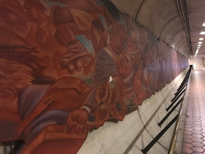
I think that one of the most interesting things about this station, which is pretty unremarkable otherwise, is that there is some really cool art there, most notably a two-part piece called "Homage to a Community," by Andrew Reid and Carlos Alves.

The main mural is 130 feet long and depicts major events in the neighborhood from Native Americans, featured at the far right of the mural, to modern-day commuters on the end at the left. I looked this up on the WMATA website and the difference in color from when it was new in 2002 to now is shocking.
View down the Metro entrance tunnel showing a mural running the length of the wall.
In terms of square footage, that is a lot of art.
Photo of a section of the mural from a head-on perspective
According to an article I found, this section features Duke Ellington and the U Street community.
I wish I'd known about this mural and what it represented prior to walking pretty quickly past it. I imagine it must be kind of neat to commute through that station every day and be able to see different parts of it. Frankly, it's way better than the walls of ads at most stations.

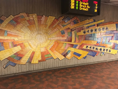
The mural is complemented by a tile piece on a nearby wall that adds a nice touch of color. It's very pretty and brightens up what are usually pretty grim surroundings. Let's be honest here, WMATA hasn't spent a lot of energy making Metro entrances appealing.

A colorful cracked tile piece of art that looks a little like a sunburst.
Not being "smart" about art, I'm not entirely sure what this "means."
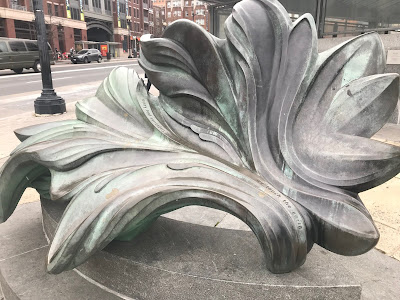
There is more art outside in the form of a leaf titled "New Leaf" that was installed in 2007.
Photo of a sculpture of a leaf
I'm willing to bet this gets used as a bench/leaning platform pretty regularly.
So there's the station. Now what about the run? I chose to run the day I did (a Saturday) because snow was in the forecast and I really love running in falling snow. I also knew that if I ran that Sunday, there would be accumulated snow and ice and I'd probably fall and hurt myself, because that is something that I do A LOT.

This run was kind of tough from the get go. It was probably the longest run I've done in a year; at the very least, it was the longest run I've done since my knee injury last March. See, I'm registered for the DC Rock N' Roll Half Marathon this March although I think I might have to bail on it because of a conflict at the same time and the fact that I'm not entirely sure I'll be ready for it. Regardless, I have a training plan and the plan for this weekend said 7 miles, so I found a Metro station 7 miles from my neighborhood to run from without considering any other factors. Oy.

I ran up Georgia from the station to Iowa and then cut across to 16th Street, which I took all the way to East-West Highway in Silver Spring. I started out pretty well, but my knee, which sometimes has a problem with uphills, started twinging a couple of miles in, slowing my already turtle-like pace. I'm a pretty slow runner. I was slow even before my injury, when I usually ran between 11- and 12-minute miles. I'm even slower than that now, but trying to work my way back.

It doesn't really matter which way you run on 16th street because it goes up and down a lot. Some of that was quite a slog. A couple of runners passed me going up one of the uphills and they turned around at the top of the hill and gave me a sympathetic nod and a "good job!" as they passed me on their way back down. I think I mighta looked like I was struggling.

Elevation graph with lots of peaks
Fun times with hills!
 All in all it wasn't bad though. My legs were really tired, but I had some great sections where I felt good. At first I was really hot and stripped off my gloves, headband, and jacket.  Eventually everything but the gloves got put back on. I finished the run pretty wet and chilly.

Selfie in front of a sign showing the border between DC & Maryland
Now I'm in DC! Now I'm in Maryland! Now I'm blocking my camera with my water bottle!
Once I got to Silver Spring, I turned west on East-West Highway, a road I've run a bunch, but not for a long time. I was prepared for the hills there, but did more shuffling than bounding up them. I was close to the bottom, not far from taking a right onto Rock Creek Trail near Jones Mill Road when I saw my husband, Alex, appear, take a u-turn at the intersection, and go back the way he'd come. I was really excited to see him, but he didn't see me and so I sped up to catch him. The only problem is that he runs significantly faster than me on my best day so I was pretty sure it was a futile acceleration. Fortunately, there is a water fountain about a tenth of a mile in from the intersection where he u-turned and I caught him.
Photo of Alex and I in the snow.
He's a very patient man.
And then he left me in the dust again. But once he got to the bottom of our neighborhood nemesis hill, he turned around and ran back to me. And then he ran back to the bottom of the hill. And then he ran back to me. It was both adorable and demoralizing. But then we got to walk up the hill together. My hip abductors were killing me on that walk. I don't know what activity works abductors so hard, but evidently I did that thing.

A quick stretch and a shower later, however, I felt much better and I was happy to cross my first non-Red Line run off my list.


STATS:

Photo of me in front of Georgia Ave Petworth station


Metro station: Georgia Ave-Petworth
Line: Green and sometimes Yellow
Distance: 6.98 miles
Time: 1:30:58
Pace: 13:02 min/mi
Crow sightings: none
Interesting tidbit: Yellow line trains don't run north to Georgia Ave-Petworth past Mt. Vernon during rush hour, which seems inexplicable, but is really because, past Mt. Vernon, there aren't any "pocket tracks" allowing the trains to move out of the way while turning around to go the other direction. Because of that, it would take too long for trains to turn around at Fort Totten during rush hour, which would cause big gaps between trains.


Sunday, January 13, 2019

Cleveland Park Run: "Clean and Free of Riff-Raff"

(The title is pulled from a Yelp review of this station by what one only assumes is a very tolerant and down-to-earth person. I didn't see her in the station the day I visited so it was, indeed, free of riff-raff.)

When I first moved to the DC area 15 years ago, I thought it was weird that there was no Metro station at the zoo. Instead there were two nearby stations and you had to walk to the zoo from there. Because I had little kids with stubby legs and whiny mouths, I always drove there instead. Hence, I had never been to the Cleveland Park Metro Station before I ran home from there on January 6, 2019.

photo of the platform of the Cleveland Park Station
Yep, that's a pretty standard Metro platform.
Both Cleveland Park and the nearby Woodley Park-Zoo/Adams Morgan Station sit near but on opposite sides of the zoo. I did learn, however that not only is Cleveland Park 106 feet closer to the zoo than Woodley Park, but the walk there is downhill.

I tried to look up things that are 106 feet so you could get an idea of much shorter of a walk it is, but I came up with results like, "it's about one-and-three-fifths times as long as a cricket pitch," and "it's about three-fifths as tall as Nelson's Column," and "it's about one-and-seven-tenths times as long as a bowling lane," and I couldn't figure out the math and also what the hell is Nelson's Column and who knows how long a cricket pitch is? Aren't they supposed to compare distances to common objects? I finally discovered that 106 feet is either about half as long as the wingspan of a 747 or twice as long as a semitrailer, so depending on whether you prefer division or multiplication, you can visualize how much shorter the Cleveland Park walk is. That said, you're going to have to walk a half mile to get there regardless and once you're at the zoo, you will have to walk up and down that giant, stupid hill the park is built on anyway.

But I digress.

This station has been in operation since 1981, only five years after Metro started running. Until recently, the escalators there were the same ones that were installed at that time. I know this because the station is in what one would hope is the end-stages of an escalator replacement that started in June 2017, resulting in adventures in staircases.

photo of a concrete stair case with wood frames over it and next to a blue contruction wall
What do you suppose those wood frames are holding up?

Photo of the mid-level landing showing a blocked off escalator under construction and an operational escalator
But see how shiny and presumably new that working escalator is!
Cleveland Park Station lets you get to street level on either side of Connecticut Avenue, which is what I ran down (and up and down and up) almost the entire way home. In fact, I ran five miles north on Connecticut Avenue and then took a right turn on Beach. Connecticut Avenue is made up of long, rolling hills and is adjacent to a lot of homes and businesses, which may be why there were approximately 65,000 runners on the sidewalk that day, every single one of them faster than me.

on left is a map of my route with the temperature and windspeed on it. at right is an elevation graphy showing a series of ups and downs.
One of these graphics is a straight line and one indicates that you have to run uphill a lot.
The day I did this run, it was unseasonably gorgeous out. It was in the mid-50's, which pretty much mitigated the headwind I ran into for the first few miles. As much as I complain about being forced to run uphill, I actually really like to run along Connecticut. There's a lot to look at, there is usually space to run around pedestrians, and lots of people take their cute dogs out there. Also, if you need to drop into a store for a bottle of water, there are approximately 67,000 CVS stores on that street.

There are a number of Metro stations all in a line on Connecticut. I'm going to have to get creative to find new, non-Connecticut ways home from them. Stay tuned for that!

STATS:

Selfie of me across the street from a Cleveland Park Station entrance


Metro station: Cleveland Park
Line: Red
Distance: 6.21 miles
Time: 1:16:29
Pace: 12:19 min/mi
Crow sightings: zero
Interesting tidbit: Metro started running in 1976, which doesn't seem that long ago, but really is.

Tuesday, January 1, 2019

Forest Glen Run: Where is the Forest? Or the Glen?

I took my very first Project Crow journey on December 9, 2018 from the Forest Glen Red Line Station. This station is the closest to my house of all of them and the route is almost entirely downhill, so this was a short, charming run.

Forest Glen Station is located on the corner of Georgia Avenue and Forest Glen Road in Silver Spring, Maryland. Probably the most interesting thing about this station is that at 196 feet deep, it is the deepest station in the whole of the system. There are no escalators, just high-speed elevators, many of which work much of the time. It is the only station that doesn't have escalators, so don't get stuck there if there is a power outage and you don't feel like walking up 21 flights of stairs.

Photo of the front of the Foorest Glen station, which is basically a big slab of concrete with an entrance in it.
Such a beautiful glen.
Evidently this station opened in 1990. It has a parking lot, although unless you're there by 9am, you will likely not get a spot. Depending on day of the week and the weather, it can fill up before then.

This station is located in Forest Glen, which is a census-designated place. I had never heard of a CDP before I started wondering about WHERE IS THE FOREST? Evidently a census-designated place is a concentration of population defined by the Census Bureau for statistical purposes only. Huh. Who knew? (Wikipedia knew.)

This run was great. Here is my route: I ran down Forest Glen Rd to Linden Lane across the railroad tracks. There are a couple of options after you cross the Beltway (I love running over highway overpasses—I don't know why. You can go the safe up Woodley Avenue then down Forsythe Avenue way or you can go on the twisty, no-shoulder Newcastle Avenue. I always take Newcastle because Forsythe Avenue is really steep. If you ever take Newcastle, be careful and be mindful of which side of the road you run on. I spend some time on the right side because there are lots of blind turns if you're on the left. After Newcastle, I ran to Jones Mill and took a right back under the Beltway and I was done! At 1.3 miles, this is definitely my shortest Project Crow journey.

map showing my route from Forest Glen to my neighborhood
It feels a lot twistier than it looks.
Graphic of the elevation of my run, which shows a steady descent from 383 feet to 195 feet.
A big reason why this run was fun.
So there you have it: my inaugural crow run—on which I saw no crows. I have, however, seen them at that station before so it is not entirely unfitting that this was my first. On to the next one!


me in front of the Forest Glen Station

STATS:

Metro station: Forest Glen
Line: Red
Distance: 1.3 miles
Time: 14:28
Pace: 11:07 min/mi
Crow sightings: zero
Interesting run tidbit: This was the first official Project Crow run!

As the Crow Runs (and Walks and Cycles)

Welcome to my new blog about my new fitness project: Project Crow — or, if it makes it easier for you, Project CRoW.  Project Crow stands for Project Cycle, Run, or Walk. During Project Crow, I will be getting home from each DC-area Metrorail station by one (or more!) of those three methods.

Metro system map in a frame with a red flag stuck into Forest Glen with a date and mileage on it
My sophisticated activity-tracking system.
I came up with this after I heard about someone who had run to every Metro station and I thought that was a really cool idea. I don't know for sure if that is a thing that happened; maybe I'll do some research on it. Regardless, I liked the idea because I get bored with running the same routes all the time so this seemed like a good way to do some exploring and motivate myself to get out the door in my running shoes.

I live in Kensington, Maryland, and will run to my neighborhood, not my house, partly so that you can't triangulate in on my address and partly because I live at the top of a bummer of a hill that I don't like to run up. In more bummer news, Kensington is net uphill from most Metro stations. That super sucks but also leads me to my next topic, which is why not just run downhill to all the stations?

I decided to run home from the stations because it is a super drag to shiver all the way home on the Metro from a winter run and it is just downright embarrassing for me and gross for others when I sweat all the way home on the Metro after a summer run. I've done both; neither is awesome.

I should probably address the cycle and walk part of Project Crow here. I am primarily a runner. In fact at the time of this writing, I could probably count my adult outdoor bicycle experiences on one hand. That said, I have had knee issues of late, so the cycle part is there in case my knee blows out and I can't run anymore. Also, do you have any idea how far away the Wiehle-Reston East station is from my house and how long it would take me to run that distance? (It's really far and a long time.)

I do have a bike, so I hope to start some riding, but I don't really want to be killed during this endeavor, so I will need to find some bike path-accessible stations. I am an avid indoor cyclist (I love me some Peloton), so hopefully by the time I get on the road, my legs will know what they're doing.

I included walking in Project Crow because sometimes I am just not feeling a run and it is nice to walk. Also because it starts with a "W."

I'm really excited to begin this project. I tend to obsess over running routes. Whenever I am in a car or on the Metro, I watch roads and paths and think about terrain and elevation and how it would be to run on it. I have my eye on a few paths that I can't wait to run on. I'm excited to plan some routes home. I'm going to try to not run the same routes all the time so we can all experience new areas of the DC Metro area. This means that I won't always be taking the shortest route home, you know, as the crow flies.

There are a lot of Metro stations — 91 to be exact, with more on the way. My home station is Forest Glen, which is the first station I have run as part of this project. It is also the start of my commute to work (Farragut North is the other end — Red Line, represent!). The farthest Metro station that I've run from is Rosslyn, although that doesn't count for Project Crow because I did it last year.

You might have read this far wondering, why crows? What is up with the crow thing? Well. Crows are badass, yes? That's pretty much it. I'm a fan of corvids in general. They're smart, they're pretty, they make funny noises, and they eat roadkill. What's not to love? In fact, I added cycling and walking to my project in part because it made Project Crow work.

That's about it. My next post will be about my Forest Glen run. If you have questions, you can ask me and if you want more information, check out my FAQ.