Tuesday, May 21, 2019

Columbia Heights Run/Walk: Trails, Paths, and, Oh! Look! More Trails!

I have been delinquent. I did a Project Crow journey weeks ago and haven't told you about it yet. I guess sometimes it's easier to do the physical work than the mental. Not that this particular trip home from Metro was easy. In fact, I had to create a whole new category for it: the Run/Walk.

So, what station? I chose the illustrious Columbia Heights Metro Station on the Green Line, disembarking just four days before someone was stabbed at the station in the middle of the goddamn afternoon on a fucking Tuesday. I went looking for more information on said stabbing and was aghast to discover that the stabbing was fatal and done with a screwdriver, before I realized that in fact the latter information was about a stabbing at the Columbia Heights Metro Station in July 2018. Then I made the mistake of Googling Columbia Heights metro stabbing, found more stabbings, and decided to stop investigating Metro station stabbings altogether.

To begin again: Columbia Heights! What a great station! Evidently this station is one of the busiest Metro stations outside of the downtown core with more than 12,000 exits on weekdays and nearly 16,000 exits on weekends.

Photo of the glass roof, stained glass decorations, and concrete walls of the Columbia Heights Station West Entrance
Pretty. And not a screwdriver in sight.
Based on my exit from the station, I believe those numbers. The area was absolutely packed. There were people playing music, vendors selling food and crafts, many shopping destinations, and so very many people milling about. I also saw this cat/astronaut.

Photo of a woman carrying a hard-shell pink frontpack with a window in which you can see her cat's head.
Catstronaut?
It looked like a hoppin' neighborhood. I headed down Irving Street toward the zoo because I wanted to find some of the trails that run through Rock Creek Park that I'd never run on before. I came to the end of Irving Street and immediately got lost and wandered in circles for a bit. Once I found the path I wanted to take, I ran down it for a couple of minutes before I realized that I'd run that direction on that path before, but at the time I'd been running away from my house, so I turned around and ran the other direction.

I wasn't entirely sure how I was going to get home. I'd made a decision to head into the park and run north until I found Maryland. I've run a similar route south into DC often, so I figured that, worst case scenario, I'd just run that in reverse. I came to a literal fork in the road about a mile and a half in when I saw the path I knew go one direction and the path I didn't know go another.

Photo of a sign in a lot of greenery. The Valley Trail points one direction, the Western Ridge Trail another.
Refrains from road less traveled joke here.
I headed off down the Western Ridge Trail, not knowing what to expect. Shortly thereafter, I got a hint when I came across this sign:

Photo of a sign that says "Western Ridge Trail." There are arrows pointing in opposite directions, one says "Strenuous" and one says "moderate."
It's almost like the sign was throwing down a dare.
You guys, the "moderate" arrow was pointing to an uphill trail and the "strenuous" arrow was pointing to a gently downhill sloping trail. Being an unthinking asshole, I passed a hiker to sprint down the strenuous trail. Shortly thereafter, when the trail took a sharp upturn and I realized that running up it was unlikely (for I was still planning on running this route at that time), I had to turn around and re-pass the same hiker on my way to the easier trail, while muttering, "I've made a huge mistake."

It turns out the "moderate" trail was not all that moderate. This seems as good a time as any to explain why this turned into a run/walk instead of my planned run. 
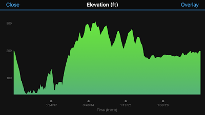
graph of the elevation of my run. There is a lot of up and down, especially at the start.
There were stairs on the trail, people. STAIRS.
I tried to run as much as possible for a long time, but eventually I realized that I could no longer in good conscience refer to this as a run. However, I'd already run (and continued to run) more than I would on a walk, so I created a new Crow category. Deal with it.

The moderate and strenuous trails met up before too long and I managed to stay on trails that I'd never run on before. I'd actually been really excited for this route because I've driven on roads that run near these trails and paths many times and I've always wanted to put foot to dirt and asphalt on them. I was delighted to find that I had quite literally stumbled on to them.

This route wasn't the easiest, but I really, truly enjoyed it. There were enough water fountains and spigots that I ran into along the way to keep my water bottle filled and it was maybe the prettiest run I've taken through DC.
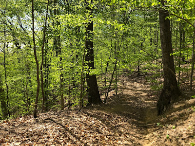
Photo of a dirt path through bright green trees.
I mean, come on.
At times I did feel like I was on the very trails that that hapless jogger who finds bodies runs on. Mostly I just found people with dogs. (Phew.)

Rock Creek Park kind of floors me. It is incredible to me that there is this giant, gorgeous park right in the middle of DC that seems miles away from everything. There was a 10-15 minute stretch where I literally saw no one. Literally. Where in DC can you say that?

I was pretty sure that I was headed in generally the right direction, but I was still happy to find a sign indicating that I was approaching my home state.
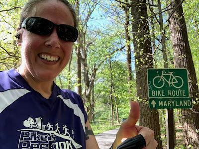
Photo of me giving a thumbs up next to a bike route sign indicating that Maryland is thatta way.
Maryland is thatta way!
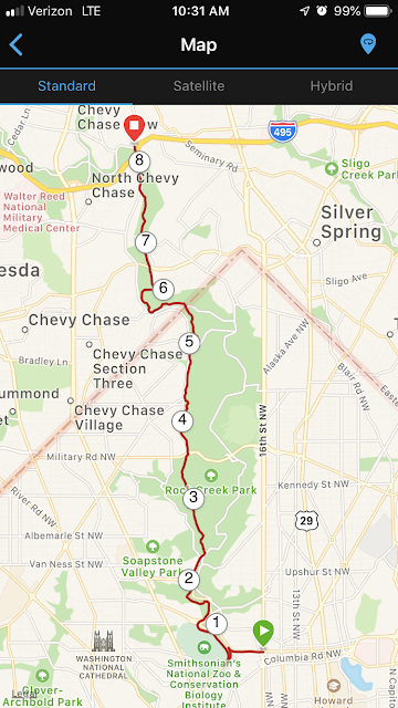
Eventually I popped out of the woods at the DC/Maryland line, which is a turn-around spot for a lot of my local runs. Victory! But then I still had to run three miles to get to my neighborhood.

Screenshot of a map of my route.
A nice little jaunt, if I do say so myself.
I'm so happy that I challenged myself to take a different route than usual. In fact, I might even do this route again and try to run the whole thing. I love that I can run 8 miles through the heart of the DC area and touch almost no roads. I might even branch off these trails onto new trails. There is a lot of park to explore out there!

STATS:

Selfie of me in front of the Columbia Heights Station sign

Metro station: Columbia Heights
Line: Green Line and sometimes Yellow Line
Distance: 8.37 miles
Time: 2:03:08
Pace: 14:42 min/mi
Crow sightings: Sniff. None.
Interesting tidbit: There is a Target right next to this station, which meant I could use the bathroom before I started running. Game changer, right there.

No comments:

Post a Comment